

PEMETAAN FAKTOR C YANG DITURUNKAN DARI BERBAGAI INDEKS VEGETASI DATA PENGINDERAAN JAUH SEBAGAI MASUKAN PEMODELAN EROSI DI DAS MERAWU (C Factor Mapping Derived from Various Vegetation Indeces of Remotely Sensed Data for Erosion Modeling at Merawu Catchment
Bambang Sulistyo(1*), Totok Gunawan(2), Hartono Hartono(3), Danoedoro Danoedoro(4)
(1) Fakultas Pertanian Universitas Bengkulu
(2) Fakultas Geografi, Universitas Gadjah Mada
(3) Fakultas Geografi, Universitas Gadjah Mada
(4) Fakultas Geografi, Universitas Gadjah Mada
(*) Corresponding Author
Abstract
ABSTRAK
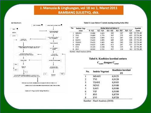
Penelitian ini bertujuan untuk mengkaji berbagai indeks vegetasi yang diturunkan dari data penginderaan jauh dalam pemetaan faktor C sebagai masukan dalam pemodelan erosi USLE (Universal Soil Loss Equation). Metode yang digunakan dalam penelitian ini adalah dengan menganalisis data penginderaan jauh Landsat 7 ETM + sehingga menghasilkan berbagai indeks vegetasi yang kemudian dilakukan analisis korelasi dengan Faktor C yang diukur di lapangan pada 45 lokasi. Dari analisis ini diperoleh suatu model untuk pemetaan faktor C (C model ) dari berbagai indeks vegetasi. Peta faktor C yang diperoleh kemudian dilakukan validasi pada 48 lokasi sehingga akan diketahui keakuratan hasil pemodelan. Dalam penelitian ini dikaji 11 (sebelas) indeks vegetasi yang diturunkan dari data penginderaan jauh, yaitu ARVI, MSAVI, TVI, VIF, NDVI, TSAVI, SAVI, EVI, RVI, DVI, dan PVI. Hasil penelitian menunjukkan bahwa dari 11 indeks vegetasi yang dikaji terdapat 8 indeks vegetasi yang menghasilkan peta faktor C dengan ketelitian yang tinggi, yaitu MSAVI, TVI, VIF, NDVI, TSAVI, SAVI, EVI, dan RVI. Indeks vegetasi yang menggunakan rumus yang lebih kompleks menghasilkan koefisien korelasi yang lebih tinggi dibanding dengan indeks vegetasi yang menggunakan rumus yang sederhana. Indeks vegetasi yang mempertimbangkan latar belakang tanah (MSAVI dan TSAVI) mempunyai koefisien korelasi lebih tinggi dibanding dengan koefisien korelasi yang tidak mempertimbangkan latar belakang tanah.
ABSTRACT
The research was aim at studying C factor mapping derived from various vegetation indices of remotely-sensed data as input for USLE (Universal Soil Loss Equation) erosion modeling at Merawu Catchment. Methodology applied was by analyzing remote sensing data of Landsat 7 ETM+ to obtain various vegetation indices for correlation analysis with C Factor measured directly from 45 locations on the field. The analysis resulted models for C factor mapping from various vegetation indices (Cmodel). These C factor maps were validated using 48 locations on the field to know their accuracies. These research used 11 (eleven) vegetation indices of remotely-sensed data, namely ARVI, MSAVI, TVI, VIF, NDVI, TSAVI, SAVI, EVI, RVI, DVI and PVI. The research result showed that from 11 vegetation indices there were 8 vegetation indices resulted high accuracy of C factor maps, i.e. MSAVI, TVI, VIF, NDVI, TSAVI, SAVI, EVI and RVI. Vegetation indices using more complicated formulae resulted higher correlation of coefficient compared to those vegetation indices using simpler formulae. Vegetation indices that account for soil background (MSAVI and TSAVI) resulted higher correlation of coefficient compared to those vegetation indices without considering soil background
Full Text:
Artikel lengkap (PDF) (Bahasa Indonesia)Article Metrics
Refbacks
- There are currently no refbacks.
Copyright (c) 2017 Jurnal Manusia dan Lingkungan
JML Indexed by: