

PEMODELAN FAKTOR K BERBASIS RASTER SEBAGAI MASUKAN PEMODELAN EROSI DI DAS MERAWU, BANJARNEGARA, PROVINSI JAWA TENGAH (Modeling of Raster-Based of K Factor as Input for Erosion Modeling at Merawu Catchment, Banjarnegara, Central Java Province)
Bambang Sulistyo(1*)
(1) Fakultas Pertanian, Universitas Bengkulu, Jalan WR. Supratman, Kandang Limun, Bengkulu 38371.
(*) Corresponding Author
Abstract
ABSTRAK
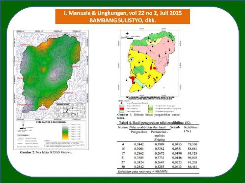
Penelitian ini bertujuan untuk mengkaji ketelitian absolut pemodelan faktor K berbasis raster sebagai masukan dalam pemodelan erosi Universal Soil Loss Equation (USLE) di Daerah Aliran Sungai (DAS) Merawu, Banjarnegara, Provinsi Jawa Tengah.Metode yang digunakan adalah dengan mengambil 30 sampel tanah secara stratified random sampling berdasarkan bentuklahan DAS Merawu. Sampel tanah tersebut kemudian dianalisis di laboratorium sehingga diperoleh tekstur, permeabilitas, bahan organik, dan struktur yang diperlukan untuk menghitung faktor K menggunakan rumus yang sudah ada. Dari 30 sampel yang diambil, 24 sampel digunakan untuk menghitung faktor K dalam pemodelan, sedangkan 6 sampel lainnya digunakan sebagai uji model. Pengeplotan nilai K pada sampel di atas peta dilakukan sesuai dengan lokasi sampel, kemudian dilakukan digitasi dan rasterisasi dan dilakukan interpolasi spasial untuk memperoleh Peta K untuk setiap piksel dengan metode Kriging. Hasil pemodelan K tersebut (Kmodel) kemudian diuji pada 6 lokasi (Kaktual) untuk mengetahui ketelitian pemodelan. Kmodel dikatakan teliti jika memiliki nilai ≥ 80% terhadap Kaktual.Hasil penelitian menunjukkan bahwa pemodelan faktor K berbasis raster di DAS Merawu mempunyai ketelitian melebihi nilai ambang yang ditetapkan, yaitu sebesar 89,068%, yang menunjukkan bahwa peta hasil pemodelan menggunakan analisis Kriging dapat digunakan untuk analisis lebih lanjut dalam menghitung erosi.
ABSTRACT
The research was aimed at knowing the absolute accuracy of modeling of raster-based K factor as input for Universal Soil Loss Equation (USLE) erosion modeling at Merawu Catchment, Banjarnegara, Central Java Province. Methodology applied was by taking 30 soil samples of stratified random sampling based on landform of Merawu Catchment. Those 30 soil samples then were analised in a laboratory to get their texture, permeability, organic matter, and structure for K factor computation using the existing formula. From 30 soil samples taken, 24 samples were used to model K factor, while the other 6 soil samples were used for Model Validation. The result of computation for each sample then was plotted according to their position, digitized, transformed and spatially interpolated using Kriging technique to gain Map of K factor of the study area (Kmodel). Kmodel then was validated with 6 soil samples of the Kactual to know the accuracy of the model. Kmodel is said to be accurate when its accuracy is ≥ 80% when compared to Kactual. The research result at Merawu Catchment showed that modeling of raster-based K factor reached the accuracy of ≥ 80%, that was 89.068%, indicating that modeling of factor K by using Kriging analysis can be used further for erosion analysis.
Keywords
Full Text:
Artikel lengkap (PDF) (Bahasa Indonesia)References
Anonim, 2009. Peraturan Menteri Kehutanan RI Nomor : P. 32/Menhut-II/2009 tentang Tata Cara Penyusunan Rencana Teknik Rehabilitasi Hutan dan Lahan Daerah Aliran Sungai (RTkRHL-DAS). Jakarta.
Arsyad, S., 2010. Konservasi Tanah dan Air. Edisi kedua. IPB Press. Bogor.
As-syakur, A.R., 2008. Prediksi Erosi dengan Menggunakan Metode USLE dan Sistem Informasi Geografis (SIG) Berbasis Piksel di Daerah Tangkapan Air Danau Buyan. Pusat Penelitian Lingkungan Hidup Universitas Udayana. Denpasar.
Bahrami, H.A., Vaghei, H.G., Vaghei, B.G., Tahmasbipour, N., dan Taliey-Tabari, F., 2005. A New Method for Determining The Soil Erodibility Factor based on Fuzzy Systems. Journal of Agriculture Science Technology, 7:115-123.
Chang, K.T., 2008, Introduction to Geographic Information Systems, McGraw-Hill International Edition, New York.
Clifford, N., dan Valentine, G., 2006. Key Methods in Geography, SAGE Publications, London.
DeMers, M.N., 1997. Fundamental of Geographic Information Systems, John Wiley & Sons, New York.
Fistikoglu, O., dan Harmancioglu, N.B., 2002. Integration of GIS with USLE in Assessment of Soil Erosion, Water Resources Management, 16:57-68.
Hardjowigeno, S., 2007. Ilmu Tanah. Edisi baru. Jakarta. Akademika Pressindo.
Kartodihardjo, H., 2008. Pengelolaan Sumberdaya Alam dan Lingkungan Hidup, Seminar Lingkungan Hidup dan Sumberdaya Alam, Universitas Bengkulu, Bengkulu; 20 April 2008.
Karydas, C.G., Petriolis, M., dan Manakos, I., 2013. Evaluating Alternative Methods of Soil Erodibility Mapping in the Mediterranean Island of Crete, Agriculture, 3:362-380.
Pazhouhesh, M., Gorji, M., Taheri, S.M., dan Keshavarzi, A., 2011. Determination of Soil Erodibility Factor Using Fuzzy Rule Base System, International Journal of Environmental Sciences, 1(7):1874-1883.
Sudjana, 2002. Metoda Statistika, Penerbit Tarsito, Bandung.
Sulistyo, B., 2011. Pemodelan Spasial Lahan Kritis Berbasis Raster di DAS Merawu Kabupaten Banjarnegara Melalui Integrasi Citra Landsat 7 ETM+ dan Sistem Informasi Geografis, Disertasi. Program Pascasarjana Fakultas Geografi, Universitas Gadjah Mada. Yogyakarta.
Sulistyo, B., 2015. Kajian Perubahan Tingkat Kekritisan Lahan Sebagai Akibat Proses Eliminasi Unit Lahan (Studi Kasus Di Kawasan Pertambangan Danau Mas Hitam, Provinsi Bengkulu). Seminar Nasional Masyarakat Biodiversitas Indonesia. Universitas Gadjah Mada. Yogyakarta, 21 Maret 2015.
Wischmeier, W.H., dan Smith, D.D., 1978. Predicting Rainfall Erosion Losses : A Guide to Conservation Planning. Science and Education Administration USDA in cooperation with Purdue Agriculture Experiment Station, Purdue.
Article Metrics
Refbacks
- There are currently no refbacks.
Copyright (c) 2017 Jurnal Manusia dan Lingkungan
JML Indexed by: