

PENGGUNAAN TEKNOLOGI REMOTE SENSING DAN SIG UNTUK PENGENDALIAN DINAMIKA POPULASI SOIL TRANSMITTED HELMINTHS DI SATUAN LAHAN ENDEMIS PULAU AMBON (Use of Technology Remote Sensing and GIS to Control Population Dynamics of Soil Transmitted Helminths)
Melianus Salakory(1*), Soeyoko Soeyoko(2), Sugeng Juwono Mardihusodo(3), Sutanto Sutanto(4)
(1) Department Geography Education, FKIP-Pattimura University
(2) Department of Parasitology, School of Madicine, Gadjah Mada University
(3) Department of Parasitology, School of Madicine, Gadjah Mada University
(4) Faculty of Geography, Gadjah Mada University
(*) Corresponding Author
Abstract
ABSTRAK
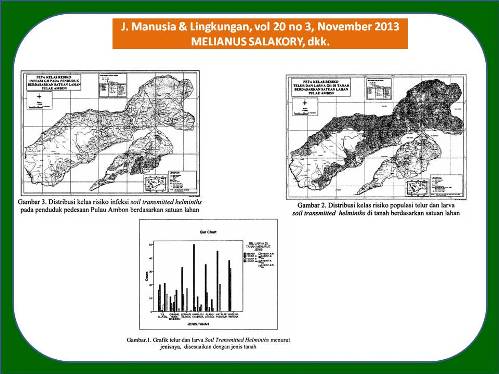
Dengan menggunakan pendekatan ekoepidemiologis, yang didukung oleh data penginderaan jauh dan aplikasi Sistem Informasi Geografi (SIG) diharapkan kejadian infeksi Soil Transmitted Helminths yang bervariasi dapat diketahui parameter lingkungan risikonya, dimonitor dinamika perubahannya, sehingga dapat dikontrol dan dikendalikan kejadian infeksi Soil Transmitted Helminths yang bervariasi dan berfluktuasi tersebut secara cepat, dan akurat. Tujuan yang ingin dicapai adalah; menggunakan Remote Sensing untuk mengkaji parameter lingkungan yang dapat digunakan dalam pengolahan peta risiko populasi telur dan larva Soil Transmitted Helminths serta risiko prevalensinya di satuan lahan Pulau Ambon. Rancangan penelitian yang digunakan adalah Experimen Semu (Quasi Experimental) di Laboratorium, ditunjang dengan Survei Lapangan (Field Survey) secara Cross sectional. Diteruskan dengan ekplorasi untuk menghasilkan peta risiko populasi telur dan larva Soil Transmitted Helminths serta risiko prevalensinya. diperoleh; parameter lingkungan risiko, populasi telur dan larva Soil Transmitted Helminths di tanah, prevalensi, serta peta risiko keduanya di Satuan Lahan endemis pulau Ambon agar dapat memudahkan pengontrolan terhadap suatu kejadian infeksi (penghematan waktu, tenaga, maupun biaya jika dibandingkan dengan suatu kegiatan surveilance).
Dari hasil interpretasi citra Landsat TM+ diperoleh data ekoepidemiologi atau lingkungan risiko Soil Transmitted Helminths. Melalui aplikasi SIG dihasilkan peta-peta tematik yaitu; peta jenis tanah, peta bentuk lahan, dan peta penggunaan lahan. Hasil tumpang tindih ketiga buah peta tersebut adalah peta satuan lahan. Populasi telur dan larva Soil Transmitted Helminths di satuan lahan aluvial berbeda dengan brunisem, gleisol, kambisol, litosol, podsolik dan rensina. Prevalensi infeksi Soil Transmitted Helminths di satuan lahan aluvial berbeda dengan brunisem, gleisol, kambisol, litosol, podsolik dan rensina. Melalui aplikasi SIG dihasilkan peta risiko populasi telur dan larva Geohelminths dan peta risiko prevalensi infeksi Soil Transmitted Helminths sehingga dapat membantu para perencana dan pengambil kebijakan dalam melakukan pengontrolan Soil Transmitted Helminths di daerah endemis pedesaan pulau Ambon. Pada satuan lahan permukiman dengan risiko tinggi dan risiko sedang dapat dilakukan kegiatan intervensi: sebagai berikut: a) penyuluhan; dilakukan kepada sasaran untuk meningkatkan pengetahuan tentang kecacingan seperti tanda-tanda atau gejala kecacingan, bahayanya, cara penanggulangan, dan pencegahan. b) pengobatan; dilakukan berdasarkan hasil pemeriksaan tinja dengan frekuensi 6 bulan sekali. c) rehabilitasi; dilakukan melalui upaya kebersihan perorangan, kebersihan lingkungan, dan perbaikan fasilitas lingkungan.
ABSTRACT
By using ecoepidemiological approach supported by the application of remote sensing data and Geographic Information Systems (GIS) expected the incidence of infection of various Soil Transmitted Helminths of this can be known the parameters of the environmental risk, monitored the dynamic of change, so that it can be controlled the incidence of infection various Soil Transmitted Helminths (STHs) which fluctuate rapidly and accurately. The aim of this research is to undestand the distribution of the STHs eco-epidemiologic conditions, the dynamic of the infective eggs and larvae population in rural areas of Ambon Island, the STH prevalence on rural population in this region, as well as the determinant factors on the dynamic of eggs and larvae growth on the soil and STHs prevalance on the population of Ambon Island. This research design uses quasi experimental at laboratory supported by the field survey with cross sectional method. Then it is continued by the exploration in order to produce a map of eggs and larvae STHs and risk prevalence. The results of the research are: the environment parameter risk, the dynamic of the infective eggs and larvae population in rural areas of Ambon Island, the prevalence on rural population in this region, as well as the determinant factors on the dynamic of eggs and (STH)l arvae growth on the soil and prevalance on the population of Ambon Island, a map of the risk of egg and larval population and the prevalence of Soil Transmitted Helminths in Ambon island residential land units in order to facilitate the control of an incidence of infection (saving time, effort, and cost when compared to a surveillance activities). The conclusion of this study is to use remote sensing data can be obtained the environmental risk STHs quickly and accurately. Through the application of GIS can be produced eggs and larvae population risk maps and prevalence of infection risk maps which could assist planners and policy makers in STHs controlling in endemic areas of the rural island of Ambon. Population of eggs and larvae of STHs in contrast to the alluvial land units brunisem, gleisol, kambisol, litosol, podzolic and rensina. Prevalence of STHs infection in contrast to the alluvial land units brunisem, gleisol, kambisol, litosol, podzolic and rensina. Settlements on land units with high risk and moderate risk of intervention activities can be carried out as follows a) counseling: done to the target to increase the knowledge of such kecacingan signs or symptoms of kecacingan, danger, way of mitigation, and prevention; b) treatment: based on the results of stool examination with a frequency of six months; c) rehabilitation: through the efforts of personal hygiene, environmental hygiene, and improvement of environmental facilities.
Keywords
Full Text:
Artikel lengkap (PDF) (Bahasa Indonesia)Article Metrics
Refbacks
- There are currently no refbacks.
Copyright (c) 2017 Jurnal Manusia dan Lingkungan
JML Indexed by: